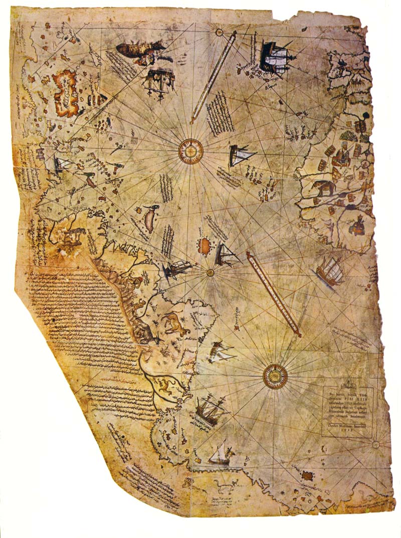
Excerpt from "Maps of the Ancient Sea Kings" by Dr. Charles Hapgood . In 1929, a map was found, painted on parchment, and dated in the month of Murharrem in the Muslim calendar year 919, which is 1513 by the Christian calendar. This map was signed with the name Piri Ibri Haji Memmed, a Turkish admiral ("Re'is") and became known as the Piri Re'is map. The map aroused interest because it appeared to be one of the earliest maps of the Americas. Examination showed that this map differed significantly from all other maps of America drawn in the 16th century in that it showed South America and Africa in correct relative longitudes. This was remarkable because navigators in the 16th century had no means of finding longitude except by guesswork. Piri Re'is made several interesting statements about his source maps. He used about twenty, he said, and stated that several had been drawn in the time of Alexander the Great. The map showed bays and islands off the Antarctic coast of Queen Maud Land now under the ice cap. This would imply that somebody mapped the coast before the ice cap had appeared (over 10,000 years ago). This map was a copy of some very ancient map that had somehow survived in Constantinople to fall into the hands of the Turks. The maps of Claudius Ptolemy, which had survived from antiquity and had been reintroduced to Europe in the 15th century. Comparing the maps, he found that the portolanos (Piri Re’is) were much better than Ptolemy's maps. Ptolemy, the most famous geographer of the ancient world, worked in Alexandria in the 2nd century A.D. in the greatest library of the ancient world. He had at his command all the accumulated geographical information of that world. He was acquainted with mathematics and showed in his great work, the Geographia, a modern mentality. The origin of the portolanos come from a culture with a higher level of technology than was obtained in medieval or ancient times.
The Greek geographers of Alexandria had source maps that had been drawn without the Eratosthenian error (from Eratoshenes ancient Greek geographer who overestimated the size of the Earth). The peoples who originated the maps possessed a more advanced science than that of the Greeks.
The general shape of the continent was startlingly like the outline of the continent on modern maps. The mountain ranges were individualized, some coastal and some not. Rivers were flowing from them into the sea in what looked like very natural and convincing drainage patterns. This suggested that the coast may have been free of ice at the time the original map was drawn. No rivers are shown in the deep interior. The source map was made, the interior was already covered by the ice cap but before the ice cap had reached the coast of Antarctica.
The shapes of North and South America have a surprisingly modern look, the west coast particularly interesting. They seemed to be about two centuries ahead of the cartography of the time. Furthermore, they appear to be drawn with highly sophisticated spherical projection. The shape of what is now the United States is just about perfect. It is very difficult to imagine how the map could have been drawn of the Pacific coast, with remarkable accuracy, in the middle of the 16th century, more than two hundred years before the solution to the problem of longitude.
Another remarkable detail of the map is the suggestion of a land bridge between Alaska and Siberia. Either the sea level was lower, or that the land has sunk since the original map was drawn with no indication of ice cover in the area.
Another ancient map, the King-Hamy map is of India. It is shown as a truncated peninsula, with a large land mass lying as an island to the south. of an ancient time when the plains of India were flooded and the southern part of the peninsula, ancient Dravidia, was an island. Because the mouths of the Ganges river, across the whole extent of India, was correctly placed, and that the map represents latitude and longitude fairly well, they proposed that Dravidia was perhaps the center of a great maritime civilization, and an advanced culture that was very old when Egypt was young. Also, there is geological evidence for the flooding of the northern plains of India, presented by A. K. Dey of the Geological Survey of India. In a paper entitled "The Shores of India", he followed elevated beaches into the interior as far north as the estuaries of the Indus. There is also literary evidence, traditions of ancient Indian literature, the Vedas, which tells of a time when Dravidia was an island.
The evidence presented by the maps indicate the existence of a civilization in remote times, well before the rise of any known civilization. It was not until the 19th century that our own civilization explored the Arctic and Antarctic, and the bottom of the Atlantic ocean. These ancient maps indicate that the makers did all these things.